The Cultural Landscape of Tuff Cities at the border of volcanoes in central Italy
Itinerary
Perugia (Umbria): lat 43,11148, long. 12.39186
Civita di Bagnoregio (VT, Latium): lat 42.62859, long. 12.11371
Orvieto (TR, Umbria): lat 42.72368, long 12.11383
https://maps.app.goo.gl/j68CHbSMx2F8YZN16
- Departure from Perugia 8.00 am
- Morning in Civita di Bagnoregio
- Lunch and afternoon in Orvieto
- Return to Perugia at 6.00 pm
Program Summary
The field trip explores a distinctive landscape shaped by both endogenous and exogenous forces along the border of the Vulsini Volcanic District, spanning the Latium, Umbria, and Tuscany regions in central Italy. The area features a narrow transitional strip between the cohesive pyroclastic caprock (volcanic plateau) and the softer Pliocene clays. The region\'s distinctive topography, featuring mesas, buttes, cliffs, pinnacles, and towers, is the result of continuous reshaping by mass movements and historical human settlement. The interaction between the natural environment and human activity has resulted in the formation of a distinctive Cultural Landscape. Ongoing geomorphological processes continue to affect these sites, prompting significant efforts to preserve the historic villages perched atop the cliffs.
Civita di Bagnoregio, situated in the Latium region of central Italy at the edge of the ancient Vulsini volcano, stands atop a towering tuff peak resting on delicate clay. This remarkably well-preserved medieval village showcases a seamless blend of cultural influences, reflected in its red-tiled stone buildings and narrow, stone-paved streets. Set within a dramatically unstable landscape, Civita exemplifies the ongoing struggle of human resilience against the relentless natural erosion of the cliff.
See more info in https://whc.unesco.org/en/tentativelists/6182/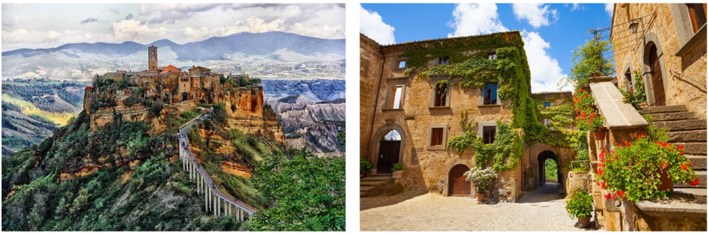
Orvieto stands atop a natural mesa, perched on a 150-meter-high tufa cliff that rises dramatically from the surrounding plains, resembling an island. The city\'s unique character is defined by the striking interplay between its sheer cliffs and the urban landscape, crowned by its majestic cathedral.
See more info in https://whc.unesco.org/en/tentativelists/344/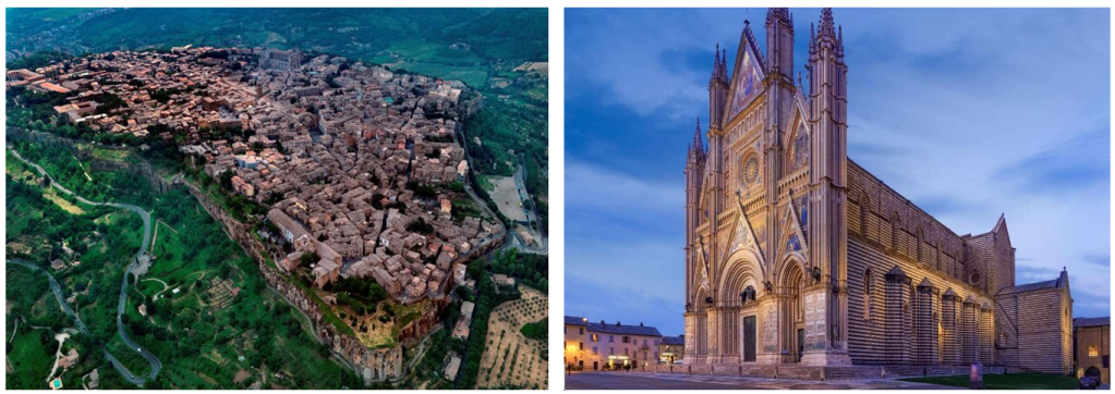
Topics:
Geomorphological arrangement and Natural Hazard
Focusing on the mesas where Civita di Bagnoregio and Orvieto are located, the geological evolution of the entire area is summarized. In particular the geomorphological arrangement clarifies the connection between mass wasting, river erosion and slope washout and the morphological evolution of the territory. Natural hazards due to seismic, gravitational, fluvial and anthropic causes are highlighted.
Quantitative methods for assessing erosion rate
The erosion processes on the basal clay control the entire geomorphological evolution of the area. A quantitative approach and the results obtained in several decades of measurements for the estimation of the erosion rate are presented starting from the observation of the badlands.
Geological heritage
Civita di Bagnoregio and Orvieto are a perfect prototype for showing how a risk derived from a geological hazard may be an economic resource. The “Geological and Landslide Museum” in Civita describes how Civita is born-again, exploiting the natural hazards as a resource. The experience of the thematic museum and the educational and touristic initiatives are proposed to underline the potential value of geodiversity, Geoheritage and geotourism on a suited territory.
Cultural Heritage
Orvieto is a city rich in architectural and archaeological values. The wonderful Cathedral (https://www.duomodiorvieto.it/en/), the Pozzo di San Patrizio (St Patrick\'s Well, https://www.orvietoviva.com/en/pozzo-di-san-patrizio/ ), the Etruscan Necropolis of Crocifisso del Tufo (https://www.orvietoviva.com/en/pozzo-di-san-patrizio/ ) and the Orvieto Underground (https://www.orvietounderground.it/index.php/en/) are just some of the city\'s highlights.